Aquifers: Long Island’s Natural Phenomenon
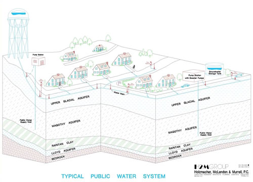
Long Island has incredible natural drinking resources below the ground called aquifers. Deep, underground layers of highly porous sand, gravel, sediment or rock, aquifers contain between 65 and 120 trillion gallons of water - enough to cover the island’s 1,200 square miles in a 300-foot flood! Water is stored in three layers. The closest to the surface is the Upper Glacial Layer, which contains water that fell between 10 and 50 years ago. No drinking water is taken from this section.
The middle layer and largest of all the formations is the Magothy Aquifer, from which the majority of Nassau-Suffolk’s public drinking water is drawn. The water here can be as much as 1,000 years old. Running from 200 to 1,000 feet deep, this layer of sand, gravel and silt was deposited about 60 million years ago and is Long Island’s main source of drinking water for its 2.7 million residents.
A Raritan clay layer is found between the Lloyd and Magothy aquifers. Most scientists believe that there are gaps in this section that allow some exchange of water between the two aquifers.
The Lloyd Aquifer is the deepest and least used layer, starting at 600 feet below the Earth’s surface. This 200-foot layer is more than 1,800 feet deep in some areas and holds the oldest water—some of it more than 5,000 years!
Click image for a larger version.
